GM Ringway – route overview
6 - 186 miles long
Overview
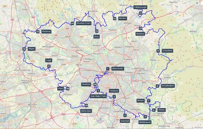
From its start in Manchester city centre, the GM Ringway – Greater Manchester’s walking trail – explores the green spaces, waterways and countryside of all ten boroughs. Green in every way, each of the 20 stages of the varied and beautiful 300-km route is designed to be accessed by public transport. By connecting the communities of the entire city-region, the trail will provide residents and visitors with a low-impact means of accessing and appreciating the area’s varied landscapes and heritage. It will also enhance public health and reduce GM’s carbon footprint by encouraging the use of public transport and active travel.
The project is led by two charities – CPRE, the countryside charity, Ramblers (Greater Manchester & High Peak Area) – and is supported by a £250,000 Heritage Fund grant.
Maps (but not full directions) for all 20 stages are now available on Plotaroute. Pages are also provided with details of each individual stage. You can follow the Plotaroute maps on your phone browser and/or print off the maps from the Plotaroute website. We will gradually be adding directions and alternative maps soon.
The route of the GM Ringway
The anti-clockwise route naturally falls into four broad sections, each made up of five one-day stages. These can be described as:
- The SOUTHERN START-UP, which uses waterways and green spaces to trace an almost traffic-free route from Manchester city centre to the edge of the Peak District.
- The EXHILARATING EAST, which explores the lovely line of hills that rise above Stockport, Tameside and Oldham.
- The NOBLE NORTH, in which five fairly challenging stages connect the dramatic peaks and valleys of the South and West Pennines within Rochdale, Bury and Bolton.
- The WESTERN WIND-DOWN, which brings the GM Ringway to a gentle finish via the wetlands, mosslands, farmland and canals of Wigan, Trafford, and Salford.
There are also plans to add western, northern and eastern link routes from the city centre to the circular route, providing even more Greater Manchester residents with direct access to the walking trail network.
Accessibility and facilities
The five stages of the “Southern Start-Up” provide a relatively easy introduction to trail walking, as they are largely level and not too long. Things get tougher during the “Exhilarating East” and “Noble North” sections because of the hilly terrain involved. All five stages of the final “Western Wind-Down” are level, though longer than the early stages of the trail.
Although the full route will not be suitable for all users because of the varied nature of the terrain, we plan to identify and publicise sections or alternative routes that are accessible to a wider user group.
How to get there
All of the trail is designed to be reachable by residents in every part of Greater Manchester as every stage starts and finishes at a public transport stop – in most cases a train or Metrolink station. In addition, many of the stages can be broken down into even shorter walks using transport options along the way.
The individual pages for each stage list the start and end points and include details of how to access these by public transport.
GM Ringway Challenges
For anyone wanting to explore more of Greater Manchester’s endless greenspaces, waterways and countryside views, the GM Ringway – Greater Manchester’s walking trail – offers the perfect solution. It’s now a whole lot easier to get outdoors, thanks to GM Ringway’s new collaboration with Go Jauntly, which means anyone can follow a walk on their phone, with simple photo-led guides.
There are two new challenges that you can complete on the Go Jauntly app. Complete all 20 stages as part of the GM Ringway Challenge or take part in 5 short routes as part of the GM Ringway Explorer challenge.
Individual stages
Stage 1
Manchester to Sale Water Park
GM Ringway Stage 1
Stage 2
Sale Water Park to Didsbury Village
GM Ringway Stage 2
Stage 3
Didsbury Village to Bramhall
GM Ringway Stage 3
Stage 4
Bramhall to Middlewood
GM Ringway Stage 4
Stage 5
Middlewood to Strines
GM Ringway Stage 5
Stage 6
Strines to Marple
GM Ringway Stage 6
Stage 7
Marple to Broadbottom
GM Ringway Stage 7
Stage 8
Broadbottom to Greenfield
GM Ringway Stage 8
Stage 9
Greenfield to Newhey
GM Ringway Stage 9
Stage 10
Newhey to Littleborough
GM Ringway Stage 10
Stage 11
Littleborough to Norden
GM Ringway Stage 11
Stage 12
Norden to Bury
GM Ringway Stage 12
Stage 13
Bury to Bromley Cross
GM Ringway Stage 13
Stage 14
Bromley Cross to Blackrod
GM Ringway Stage 14
Stage 15
Blackrod to Wigan
GM Ringway Stage 15
Stage 16
Wigan to Leigh
GM Ringway Stage 16
Stage 17
Leigh to Irlam
GM Ringway Stage 17
Stage 18
Irlam to Altrincham
GM Ringway Stage 18
Stage 19
Altrincham - Stretford
GM Ringway Stage 19
Stage 20
Stretford - Manchester
GM Ringway Stage 20